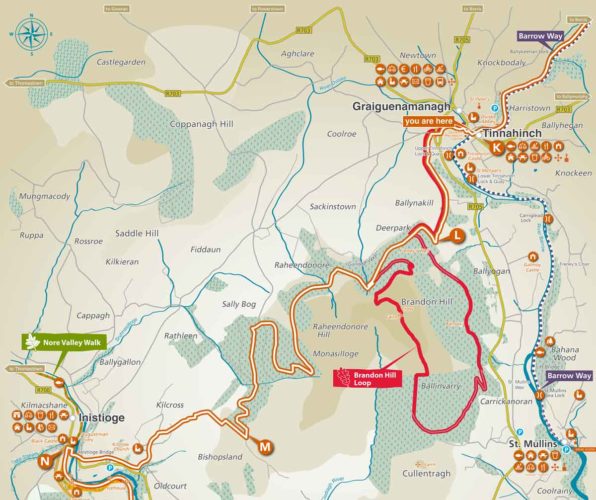
Trailhead: Tinnahinch, County Carlow
Services: Tinnahinch, Graiguenamanagh and Inistioge
Distance/Time: 17.0km / approx. 5 hours
Difficulty: Medium to hard
Terrain: Forest tracks, hillside paths and minor roadways
Ascent: 490 metres
To suit: Experienced walkers
Minimum gear: Hiking boots, rain gear, fluids, snacks and mobile phone
OSI maps: OSI Discovery Series 68, 75 and 76. The Blackstairs, Mount Leinster and the Barrow Valley from East West Mapping www.eastwestmapping.ie
Type of trail: National Way Marked Trail – yellow arrow on black background
Emergency services: 999 or 112
Contact email: secretar@carlowcoco.ie
Tinnahinch, on the Carlow side of the River Barrow, and Graiguenamanagh on the Kilkenny side, are popular boating centres whose character reflects a bygone time when the area was an important focal point for commercial traffic on the river. Both towns are connected by a beautiful bridge, constructed in 1767 when the canal system was being built.
One of Ireland’s finest Cistercian monasteries was founded here in 1204 by William Marshal who became Lord of Leinster following his marriage to Strongbow’s daughter Aoife de Clare. It was called Duiske Abbey from the stream that flows nearby. The church was restored in 1974-80 and consists of a nave and chancel with an aisle on each side. To truly imagine what the church must have been like when the monks lived here, take a look at the model of the original monastic settlement in the interior of the church. The first monastery would have spread over some five acres. In the graveyard to the south of the chancel there are two small granite high crosses. These would have been important educational tools of the time, bearing stories of early biblical significance.
Tinnahinch Castle was built around 1615 by James Butler who later lost his lands because of his involvement in the Confederate War of 1641. It was built to control a crossing where a wooden bridge once spanned the River Barrow. The castle was burnt around the year 1700 and has lain that way ever since.
K-L: Turn into Graiguenamanagh across the bridge and then turn left up a narrow lane. Reach a higher road and keep left. After a short distance, turn right up into a small cul-de-sac. The Way then crosses over a main road and continues on a minor road on the far side. After 50 metres, turn left onto a laneway that climbs steadily uphill with fine views across the Barrow Valley.
L-M: Enter the forest and continue climbing uphill on forest roads. You soon have an option to follow and enjoy fine views from the Brandon Hill Loop Walk. This will add 10 kilometres to the day and require approximately 3 hours before rejoining the South Leinster Way further on. Otherwise follow the forest roads up and around the flanks of Brandon Hill. A short detour can be made to visit Freney’s Well. After a few kilometres, the forest roads descend to exit the forest overlooking the Nore Valley and Inistioge.
M-N: Descend on tracks to reach tarmac road near Kilcross Church. The final descent to Inistioge Bridge is down a steep laneway.
‘Leave no Trace’ Principles
- Plan ahead and prepare
- Be considerate of others
- Respect farm animals and wildlife
- Travel and camp on durable ground
- Leave what you find
- Dispose of waste properly
- Minimise the effects of fire
Practising a ‘Leave no Trace’ ethic is very simple. Make it hard for others to see or hear you and leave no trace of your visit.
For more information on County Carlow visit the Carlow Tours app, available as a free download from the Google App Store or log on to www.carlowtourism.com
