Trailhead: Borris, County Carlow
Services: Borris, Myshall and Bunclody
Distance/Time: 10.6km / approx. 4 hrs
Difficulty: Hard
Terrain: Forest tracks, hillside paths and minor roadways
Ascent: 420 metres
To suit: Experienced walkers
Minimum gear: Hiking boots, rain gear, fluids, snacks and mobile phone
OSI maps: OSI Discovery Series 68, 75 and 76. The Blackstairs, Mount Leinster and the Barrow Valley from East West Mapping www.eastwestmapping.ie
Type of trail: National Way Marked Trail – yellow arrow on black background
Emergency services: 999 or 112
Contact email: secretar@carlowcoco.ie
Borris is a Georgian, granite town, full of charm and heritage nestling in the fertile valley of the River Barrow.
Upper Borris was largely built by the McMorrough Kavanagh family who trace their ancestry directly to Dermot McMorrough, King of Leinster. It is characterised by the numerous 19th century granite buildings which give the town its epithet ‘Granite Town’. Central to this section is the lodge and gateway into Borris House, a uniquely Irish ‘Big House’. The carefully chosen site at Borris, in the midst of the Blackstairs Mountains on high ground adjacent to the main communication routes, has been home to the family since the 15th century.
The town prospered in the 1800s as Arthur McMorrough Kavanagh, the landlord of the time, developed a sawmill and a thriving lace-making industry – Borris Lace soon became famous for its beautiful, intricate patterns and found its way to stately homes as far away as Russia. He also instigated the building of the spectacular 16-arch viaduct, situated at the lower end of the town, which carried the now defunct Great Southern and Western Railway Line between Bagenalstown and Palace East in County Wexford. A pleasing feature of the town is the Sacred Heart Church, built in 1820 with a façade of granite decorated with limestone which incorporates a Romanesque style doorway.
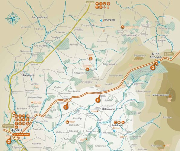
D-E: Walk downhill through Borris and take the first left turn after the Bank of Ireland onto a minor road before crossing the bridge. The impressive Borris Viaduct lies to your right. A pleasing 3.5km walk around and under the viaduct, developed by Borris Tidy Towns can be enjoyed at this point. Then keep left at the next fork and right at the following to reach a T-junction at Spahill Crossroad. Turn left and continue uphill, keeping right at the next road fork to reach Cashel Crossroad. Turn right.
E-F: Leaving Cashel Crossroad, turn left and uphill. There are fine views towards Mount Leinster, Knockroe and the source of the Mountain River which you crossed earlier. Reach Tomduff Crossroads where nearby you can find a monument to the Tomduff Campfield, where a large force of pikemen gathered in the 1798 rebellion.
F-G: Continue straight through Tomduff Crossroads and carry on uphill on a narrow mountainy road which has cattle grids to control movement of farm stock. Watch out for local landmarks, the Scabby House on your right and further on the White Rock up on the left. Your climb finishes at the large Nine Stones car park which lies on the crest of the hill. To your right is the road to the RTÉ TV mast constructed in 1963, situated on the top of Mount Leinster, the highest peak in the Blackstairs Mountain Range. The Nine Stones offers fabulous views of the rich and colourful Carlow countryside. The origin of the viewing point’s name refers to nine shepherds lost on Mount Leinster in some distant winter storm.
‘Leave no Trace’ Principles
- Plan ahead and prepare
- Be considerate of others
- Respect farm animals and wildlife
- Travel and camp on durable ground
- Leave what you find
- Dispose of waste properly
- Minimise the effects of fire
Practising a ‘Leave no Trace’ ethic is very simple. Make it hard for others to see or hear you and leave no trace of your visit.
For more information on County Carlow visit the Carlow Tours app, available as a free download from the Google App Store or log on to www.carlowtourism.com
