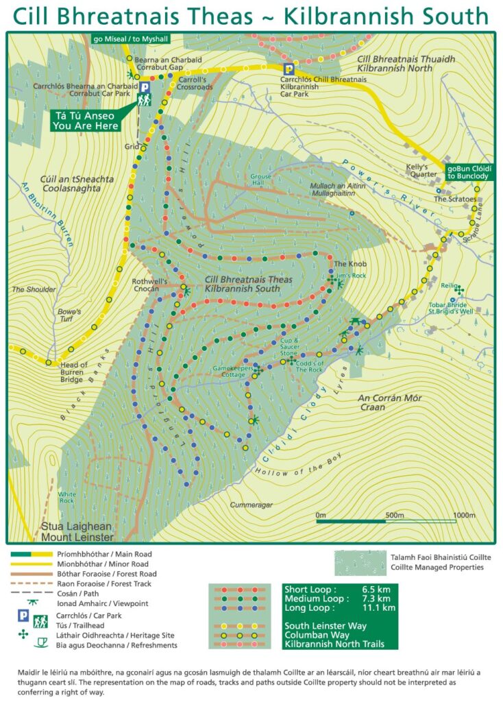
Kilbrannish South Looped Walks
Three looped walks in Kilbrannish South Forest offer routes to suit all abilities, rewarding walkers with fantastic views over the Carlow countryside.
The Short Loop (6.5 km, 2 hours, Moderate, red markers)
The shortest loop walk initially follows the tar road towards the Nine Stones before entering the forest to reach a large crossroads of forest tracks. The route then descends downhill before passing Jim’s Rock, a fine example of a quartz boulder from where fantastic views of the countryside can be enjoyed. From here, the trail returns to the road, continuing to provide stunning views across the Carlow landscape and into neighbouring counties. This walk is suitable for families and can be enjoyed with a sports-type buggy.
The Medium Loop (7.3km, 2.5 hours, Moderate, green markers) i
The Medium Loop offers a more extended forest walk, branching off from the Short Loop route at Jim’s Rock before descending deeper into the woodland. From here, the trail joins part of the South Leinster Way, guiding walkers through quieter forest tracks and open hillside. Along the way, expansive views unfold across the surrounding countryside, making this route a rewarding option.
The Long Loop (11.1km, 4 hours, Strenuous, blue markers)
The long, looped walk, branches off from the short route at Jim’s Rock before descending by historic landmarks including the Cup and Saucer, the Gamekeepers Cottage and Codd’s of the Rock. The Cup and Saucer Stone is a large square shaped granite boulder, while the Gamekeepers Cottage reflects the area’s historical land use and farming practices from earlier times. Gamekeepers Cottages would have been typical in rural forested estates where game keeping was part of land management and hunting traditions. Codd’s of the Rock refers to an area lived in by a local family, many of whom subsequently emigrated to the United States. Newly developed resting areas below the Gamekeeper’s Cottage and at the River Viewing Point offer the perfect place to pause, unwind and enjoy the stunning views over Blackrock Mountain and the Moats of Craan. The route then returns by the three historic landmarks, travelling deeper into the forest before climbing an old track steadily back uphill. The walker will be rewarded with particularly fine views at several locations around this route.
Classification of Trail Difficulty
| Easy | Generally flat trails with a smooth surface and some gentle slopes or shallow steps. These trails are generally suitable for family groups including children and the elderly. Normal outdoor footwear can be worn. |
| Moderate | These trails may have some climbs and may have an uneven surface where the going is rough underfoot with some obstacles such as protruding roots, rocks, etc. The routes are appropriate for people with a moderate level of fitness and some walking experience. Specific outdoor walking footwear and clothing is recommended. |
| Strenuous | These are physically demanding trails, which will typically have some sections with steep climbs for long periods and the going underfoot can be extremely rough including many obstacles. Suitable for users accustomed to walking on rough ground and with a high level of fitness. Specific outdoor walking footwear and clothing required. |
| Very Difficult | These routes are predominantly in remote upland areas. They will typically include steep slopes and very variable and rough underfoot conditions on sometimes indistinct trails. They may be unmarked so the use of a map and navigational skills will be required. Suitable only for the very fit and competent mountain walkers with a high level of experience. Specific outdoor walking footwear and clothing required. |